Subscribe to the most advanced commercial spatial intelligence

Running on top of the Tensorglobe platform, this subscription-based cloud environment gives you on-demand access to high-resolution satellite imagery tasking and millions of sq km of 2D and 3D basemaps for advanced analytics.

The Vantor™ Hub advantage

solution-portal.png

Access the highest-quality intelligence on-demand

solution-portal.png

The best insights are derived from the best intelligence. The Vantor Hub allows you to task Vantor's imaging satellites, explore our historical imagery archive, and download and stream global-scale 2D and 3D maps. You can also take advantage of our AI-powered computer vision models to start analytical workflows in a matter of minutes.

Power your workflows with simple APIs

solution-portal.png

Integrate Vantor’s capabilities directly into your workflows through APIs that come with interfaces that are easy to understand, simple to integrate, and clearly priced. Our APIs offer a STAC-compliant catalog, extensive reference documentation, user guides, and language-agnostic boilerplate code.

Operate securely with transparent pricing

solution-portal.png

We know you can't compromise on security or transparency. The Vantor Hub is built with security at its core, including a multi-tiered firewall. The web portal is built around a credits model with transparent pricing that ensures you only pay for what you stream or download. One subscription, unlimited seats for users.

Vantor products accessible via the Hub

WorldView™ Tasking

Never miss a critical moment with real-time tasking

The Vantor Hub gives you access to WorldView 2D task our imaging satellite constellation. Collectively, these satellites revisit the same location on Earth up to 15x per day and can collect ~7 million sq km of imagery per day, the equivalent of the Australian landmass, ensuring you get the insights you need on a relevant timeline.

Learn More

Archive Imagery

See 20 years of change, anywhere in the world

The Vantor Hub contains a 20-plus-year archive of Vantor's highly accurate, high-resolution imagery. It includes more than 6 billion sq km of imagery at 30 cm resolution and 4 m CE90 accuracy. Collectively, this archive represents the deepest reference set for global change, which is critical for training AI/ML models.

Vivid™ Mosaic Basemaps

Map the world in seamless, stunning 2D

Vantor’s visually seamless Vivid Mosaic products offer the resolution and accuracy needed for advanced mapping, visualization, and monitoring. Powered by AI-driven change detection, these products include up-to-date 15 cm HD basemaps—covering the most populous and high-interest areas of the world—a 30 cm HD basemap that covers 99% of the world, all with <5 m CE90 accuracy.

Learn More

Vivid™ Terrain 3D data

Visualize the world in immersive detail

Our Vivid Terrain products represent the most accurate 3D replica of Earth. We offer more than 100 million sq km of visually stunning 3D data—covering 95% of the highest areas of interest—which comes with real textures and is accurate to within 3 m in all dimensions. We offer multiple 3D data types to serve a wide range of missions.

Learn More

Analytics

Monitor change, detect patterns, identify threats

The Vantor Hub offers AI-powered analytics capabilities that help you extract more insights from our intelligence. Order object detections for a single image, multiple images, or specific area of interest. You can also monitor an area of interest for new object detections prior to placing an order. Our robust models can identify and classify aircraft, vehicles, vessels, construction equipment, military equipment, and more.

Use Cases

A secure portal for your most important missions

Surveillance_Recon_Mission.png
AdobeStock_532167688.jpeg
04_burj khalifa_dubai_uae_17nov2024_252pm local_wvl.jpg
AdobeStock_333357622.jpeg
AdobeStock_347949475.jpeg

Drive real-time situational awareness

Surveillance_Recon_Mission.png

Monitor change across areas of interest, build government-grade maps and assess the impact of natural disasters or hazards.

Build the navigation apps of the future

AdobeStock_532167688.jpeg

Power large-scale, accurate digital mapping and monitor change at global scale, even in the most remote areas of the world.

Shape a more prosperous nation

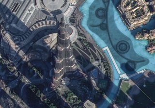
04_burj khalifa_dubai_uae_17nov2024_252pm local_wvl.jpg

Support census planning, help identify trends in urbanization, update land use/land cover layers, support flood map updates, and more.

Effectively roll out next-gen 5G networks

AdobeStock_333357622.jpeg

Monitor change related to 5G network planning as well as changes in urban environments.

Protect critical energy infrastructure

AdobeStock_347949475.jpeg

Monitor pipelines and other infrastructure assets, and create and maintain accurate maps.

Tensorglobe-WITH_TEXT.jpg
Our Spatial Intelligence Platform

Connect your systems with Vantor's spatial intelligence platform

The Vantor Hub runs on top of the Tensorglobe platform, which represents the most advanced multi-sensor spatial intelligence software suite. It enables you to build your own living digital replica of Earth, automating the entire intelligence cycle to keep it up to date and deliver total clarity across your operation.

Learn More